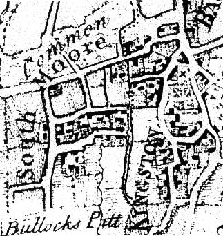
The 18th & 19th centuriesTwo separate villagesThere was much new building in Kingston Bagpuize and Southmoor in the early 18th century. The present Kingston House was built about 1720. John Rocque's map of 1761 shows a compact village centred on Kingston House with 2 village streets on either side of the house and a number of cottages long since gone. Southmoor was centred on the Town Pond area. The pond purportedly had stocks and a ducking stool. Two footpaths connected the villages. Inclosure and the Agricultural RevolutionThe Inclosure Acts (1805-6 for Kingston and 1844 for Draycott ) meant that Rights of Common were abolished. Some land had already been enclosed but these acts meant that all remaining common land and large open fields with strips were divided up between the larger tenant farmers, creating a new poor class. Rocque's map of 1761 shows a large section of Kingston village, long since demolished, in what is now open fields. Probably poorly constructed houses became derelict as people left the land and went to towns. Many buildings in Kingston Park were demolished at this time. The Kingston Inclosure map shows the Hind's Head Inn across the main Oxford Road from the present inn, which was then a bowling-green. On the other corner of the Witney and Oxford roads there was the Pound. The tollgate near the Hind's Head was for the turnpikes to Faringdon, Oxford, Witney and Marcham. Houses were then built along the turnpikes beginning the ribbon development along the A420. Along the road was The George Hotel (now the Stone House), a village green, known as the Warren beside it and the forge opposite. The 1844 Inclosure map for Draycott Moor shows no buildings on the north side of Stonehill Lane, but many on the south. Draycott Wood Estate land was farm and woodland and the Methodist Chapel at the junction of the Faringdon Road with Hanney Road was built in 1841. In the second half of the 19th century there was agricultural improvement generally but the population of 2 parishes dropped from 639 to 409.
Next: Rise and fall >> |


